Date: Saturday 25th March 2000
Time: 9:30am
Started off along top cliff path and went round to Port na Spaniah point and looked over the edge, Fulmars nesting 20 feet down safe in the knowledge that no person in their right mind would dare venture over the edge. Stopped for elevens (tea and a bite) near the deserted wartime lookout, and watched the Fulmars ride the thermals at the cliff edge. Continued on to our last stop before Port Moon and looked back to a sight equaled only by the Cliffs of Moher, shear drops off three hundred feet, not of ordinary cliff face but of the hexagonal columns that the Giant’s Causeway is so renowned. This was the first time I have ever seen such a sight and I had to stop for a while to take in the beauty…
You can hear the Skylark sing from a few hundred feet up and if your fortunate, as I was, you’ll see him. You’ll also see some Black Caps, Ravens, Fulmars and Thrushes. We went on around to Port Moon, a peaceful bay complete with fisherman’s hut still in use today by locals. You can climb down but we chose to go onward to Dunseverick. Look up quickly or you’ll miss the Buzzards in majestic flight soaring across the sky on the lookout for lunch!
Dunseverick once the home of several respected families is now in ruins with only the four corners still standing – no doubt it took a great punishment during a battle many years ago.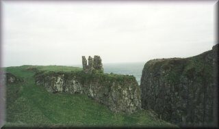 The path takes you the car park where you will see a sign with more history on the area as well as a map illustrating the path. At the other end of the car park climb another Style and follow the path around headland, we took the lower path and crossed the field at the cliff edge, there we noticed the ‘Lazy Drills’ from the time of the Potato Famine. These are drills about five feet apart that where an attempt to produce potatoes away from the blighted crop. Over another style and along the cliff edge once more, I noticed yet again more Fulmars nesting on the ledges below and I was able to get a photo from fifteen feet – class. Further on we crossed a river that I am informed has Trout, I’ve seen this river in flood before and it is a magnificent sight to see. The next bay is a favorite with fishermen and indeed there where a few, the land becomes lower here but soon we had to climb to the harbor road, follow on and make our way to the far side of the car park again crossing a style to gain access to the sea shore. As we listened to the waves crash against the rocks with a thundering roar we saw Oyster Catchers swoop across the bay and looking underfoot I saw evidence of their last meal. We climbed up the next hill and at the top was a cave that we had planned to stay and have lunch but since the weather was fine we continued through the cave around the peninsula to Portbraddan where we dropped into St Gobhan’s church tiny though it may be the caretaker has taken great care not to clutter it.
Some choose to take the cliff top path from here but we went along the shore, the tide was out, straight onto Whitepark Bay and stopped for lunch. Nothing like bacon and sausages to kill the hunger that sea gives. I imagine that the beach hasn’t changed much since the first man set foot here 8000 years ago, what a barren wild place he must have thought although evidence of deer has been found here so it must have had a wildlife. Today you’ll see the rabbits and possibly a fox. In the distance you can also see Rathlin Island. We finished the walk crossing the bay passing the sea edge to gain access to Ballintoy harbor five hours after we started.
